Many thanks to the readers who followed my training for AIDS LifeCycle, a 545 mile charity bike ride from San Francisco to Los Angeles that took place June 2-8 this year. Thanks to all the sponsors who supported my participation!
I bet you want to hear how the ride went!
In this post, I will write about the route overall, answering questions such as:
- How many miles? 545.9 total over 7 days, making it 78 miles a day on average. The route varies year-to-year depending on the road closures, road work, and whatever permits are required to roll a 3K people village down the coast. I skipped a couple of miles by skipping the last rest stop on Day 2: it was out of the way, and I just wanted to get to the camp.
- How many people? Approximately 2,200 cyclists and 650 wonderful roadies supporting us. The ride has capacity for 2,500 cyclists, and the registration for the next year is open, hint hint.
- Did you ride on PCH? Did you ride on 101? Did you ride on I-5? Yes, some of it. Yes, some of it. No: I-5 is an interstate highway; you can’t have bikes there.
Here are the actual maps, day by day, followed by a brief overview of each day.


Day 1. San Francisco to Santa Cruz. 82 miles. Elevation gain: +4,716 ft / -4,790 ft. A bit of wind, a bit of drizzle, not too bad considering how this Spring has been.
Day 2. Santa Cruz to King City. 110.6 miles. Elevation gain: +3,054 ft / -2,821 ft. This was the longest daily route of the route by 20 miles, and my first century (100 miles)! I probably rode close to 108-109 miles, having skipped the last stop; still that was a lot of miles! I felt ok physically, because the route was relatively flat, but it was a long day!
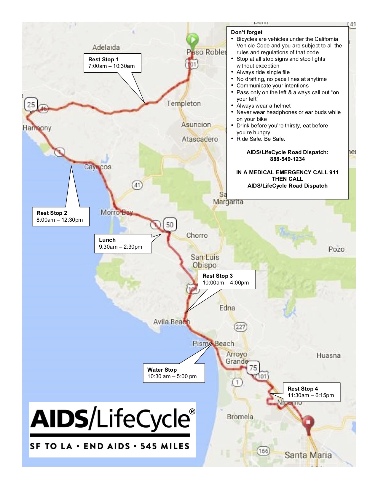
Day 3. King City to Paso Robles. 66 miles. Elevation gain: +2,569 ft / -2,173 ft. While a relatively short day, the route was all inland, Central Valley, and it was by far the hottest. The temperature got to above 100 F after lunch, and up to 107, with very little shade along the route.
Day 4. Paso Robles to Santa Maria. 88.7 miles. Elevation gain +4,796 ft/ -5,284 ft. We reached the Halfway to LA point at mile 16.9, a few miles past the first rest stop. There were a couple of steep hills in the morning, before the Halfway to LA point, aptly names the Evil Twins, but having survived Days 2 and 3, this was a piece of cake!
Day 5. Santa Maria to Lompoc. 41.3 miles. Elevation gain + 1,757 ft / -1,871 ft. The shortest and the most fun and relaxed day. Day 5, Thursday of the AIDS LifeCycle originally, years and years ago, was the Wear Red day, but that was quickly upgraded to the Red Dress day. Relatively easy ride, creativity abound, no rush, lots of time to relax at the camp in the afternoon.
Day 6. Lompoc to Ventura. 88.7 miles. Elevation gain unknown. A few hazardous spots on the descent to Gaviota, after that, a delightful, mostly flat, ride along the Ocean in the beautiful sunny Southern California. Camping at the beach at the end of the day.
Day 7. Ventura to Los Angeles. 68.6 miles. Elevation gain +2,219 ft / -1,994 ft. Nice and easy trough Rest Stops 1 and 2. Treacherous through Malibu and Santa Monica; terrifying through most of LA. But then we had our own closed out lane and lots of welcome and cheering for the last couple of miles from West Hollywood through the finish line.
You can see from the maps, that most days we had lunch and at least 4 other stops, where we could have snacks, water, and electrolyte drinks, reapply sunscreen and other ointments, go to the bathrooms, get medical and bike tech support. Even though I am not particularly athletic, the route felt easier than I thought it would be. Five hundred and forty-five miles turn out not that hard when you are carried on a cloud of support and positivity, and all you have to do is pedal among beautiful scenery.
OK, this does it for a quick overview. I have more real reflections, but they would need to wait.
